![]()
LA VALLTORTA
INICIO
MUSEO
CLIMA
VEGETACIÓN
FAUNA
DISFRUTANDO DE LA NATURALEZA
NOTICIAS
UNESCO
POBLACIONES DEL PARQUE CULTURAL
VALLTORTA-GASULLA
ELS PORTS
MORELLA
ALT MAESTRAT
CATÍ
ARES DEL MAESTRAT
BENASSAL
VILAR DE CANES
ALBOCASSER
TIRIG
PLANA ALTA
BORRIOL
COVES DE VINROMA
ARCHIVO DE ARTE RUPESTRE
TÍRIG
COVA DELS CAVALLS
COVA DEL CIVIL
COVA DELS TOLLS ALTS
COVA DEL RULL
COVA DE L’ARC
L’ARC
COVA DE LA TARUGA
ALBOCÀSSER
HISTORIA DE ALBOCÀSSER
ABRIC CENTELLES
COVETA MONTEGORDO
CINGLE DEL MAS D’EN SALVADOR
COVA DE L’ERMITÀ
COVA GRAN DEL PUNTAL
COVETES DEL PUNTAL
ABRIC DE LA MUSTELA
BARRANC D’EN CABRERA
COVES DE VINROMÀ
HISTORIA DE LES COVES DE VINROMÀ
COVES DE LA SALTADORA
COVA ALTA DEL LLIDONER
CINGLE DELS TOLLS DEL PUNTAL
COVA DE LES CALÇAES DEL MATÀ
BORRIOL
LA JOQUERA
BENASSAL
RÍU DE MONTLLOR
RACÓ DE NANDO
ARES DEL MAESTRE
EL BARRANCO DE LA GASULLA
COVA REMIGIA
CINGLE DE LA MOLA REMIGIA
LES DOGUES
NORTE DE CASTELLÓN
LA POBLA DE BENIFASSÀ
BARRANC DE LA TENALLA
LA TENALLA
COVA DEL POLVORÍN
MORELLA
MORELLA SU HISTORIA
MORELLA LA VELLA
HERNÁNDEZ PACHECO
MORELLA LA VELLA
VALENCIA
QUESA Y NAVARRES
ABRIGO DE VORO Y ABRIGO DEL GARROFERO
LÁMINAS
AYORA
TORTOSILAS
LAS PINTURAS RUPESTRE DE DOS AGUAS. CALCO
LAS PINTURAS RUPESTRES DE DOS AGUAS - VALENCA. PDF
MISCELÁNEA
LA SARGA. SUPERPOSICION
MACROESQUEÁTICO SOBRE
LEVANTINO
VIDEOS
ARTE LEVANTINO
COVA DEL PARPALLÓ
CINGLE DE LA MOLA REMIGIA
ARCHIVOS DE LA PREHISTORIA
COVA DEL CIVIL EN 3D
TUTORIAL DSTRETCH
ARCHIVOS Y PDF: DESCARGAS
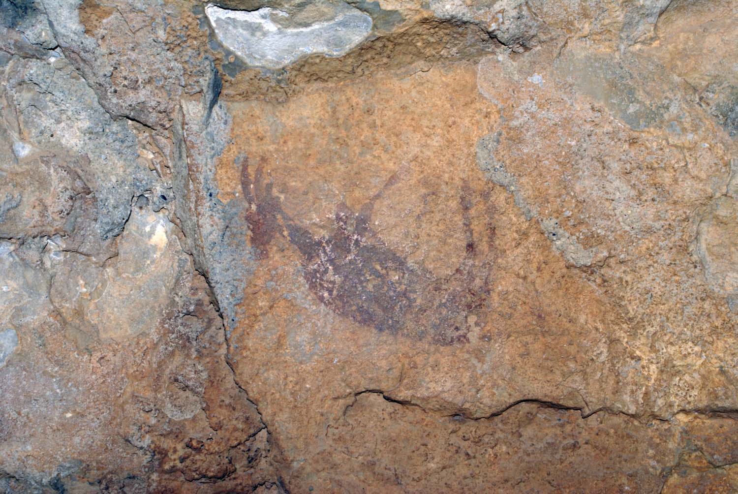
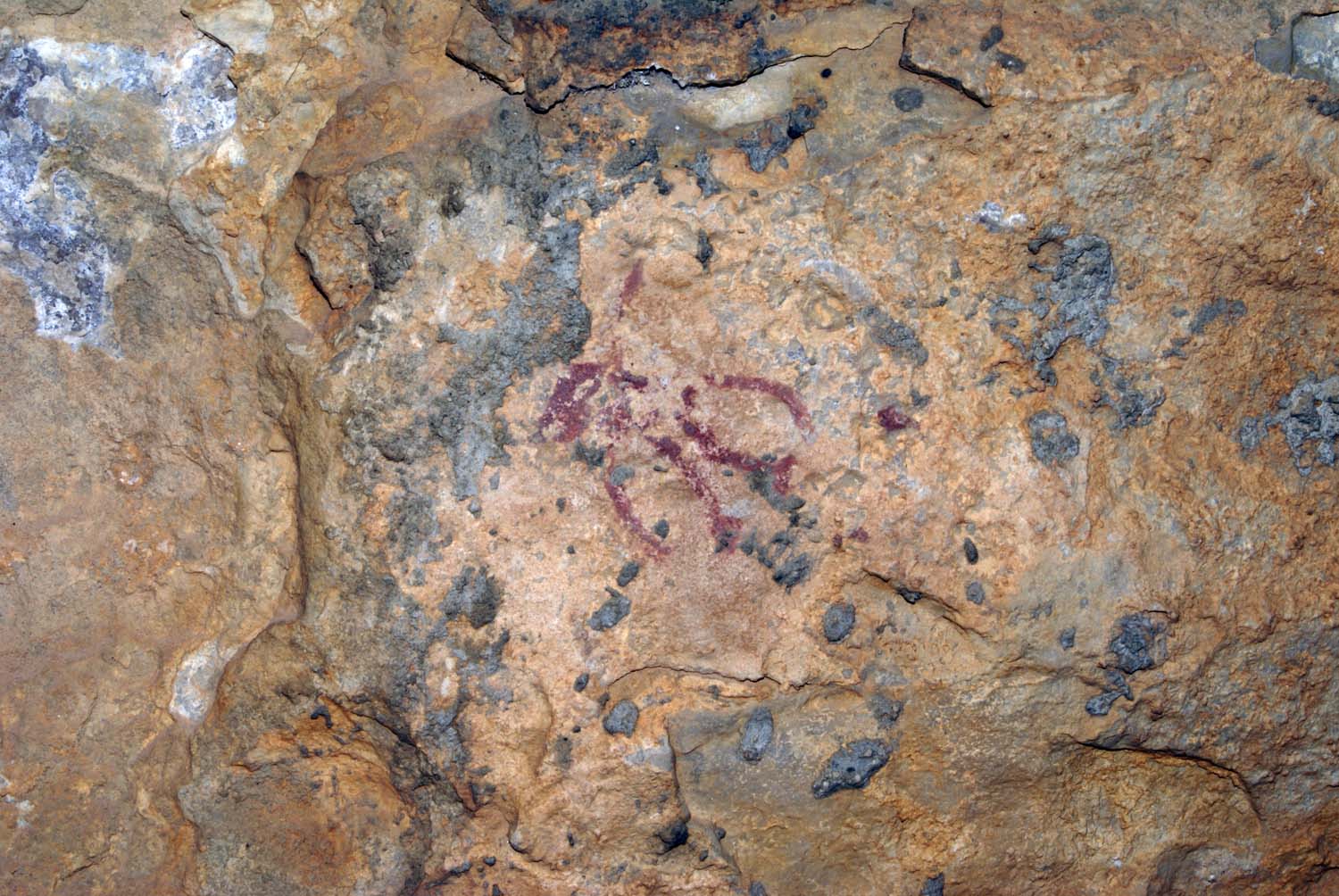
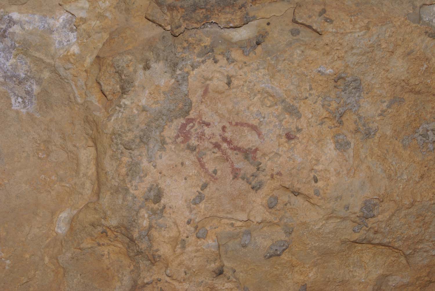
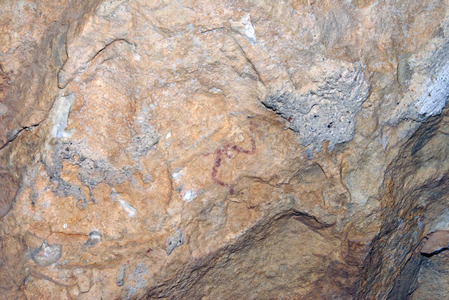
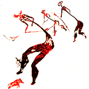
Cova del Polvorín o dels Rossegador
ESPAÑOL
Termino municipal: La Pobla de Benifassà
Comarca: Baix Maestrat
Coordenadas UTM: 31T X=266535; Y=4506218 Altura: 450 m
Antecedentes
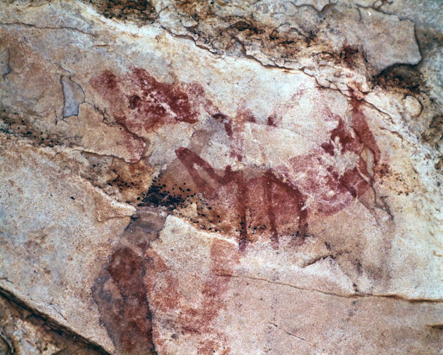
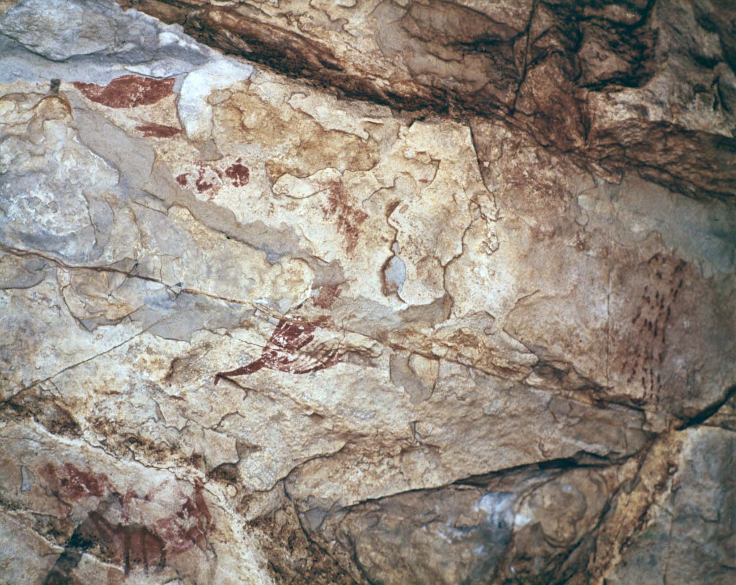
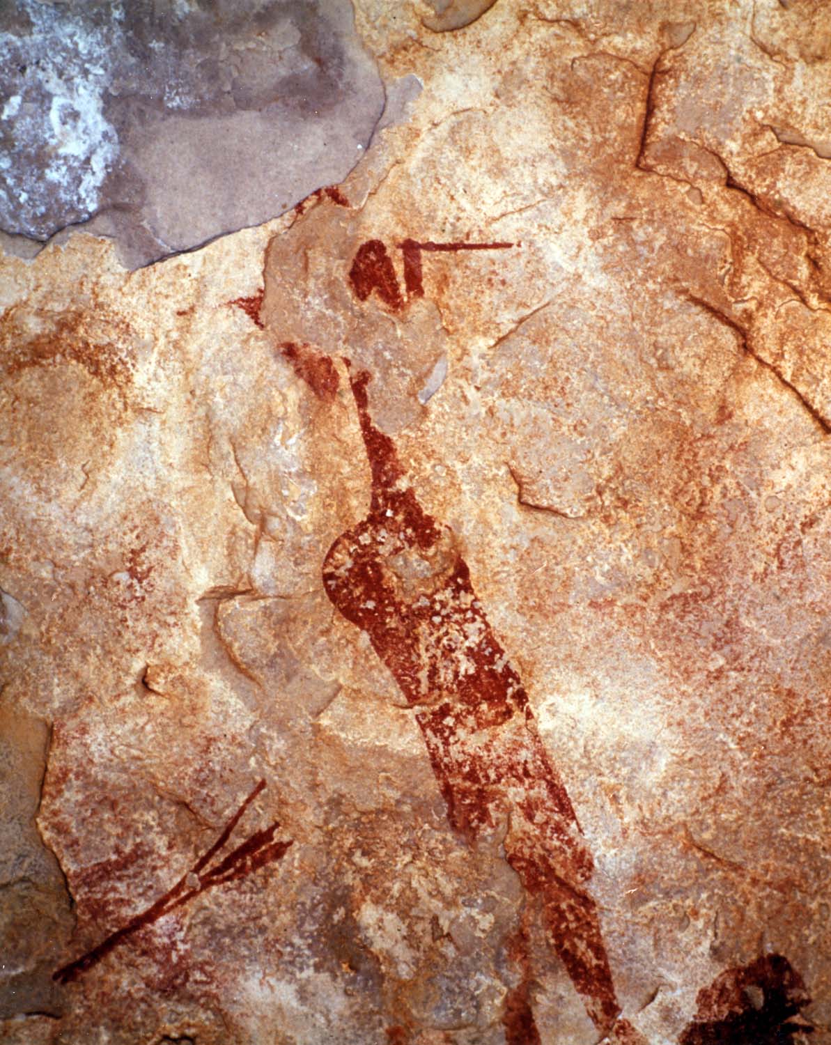
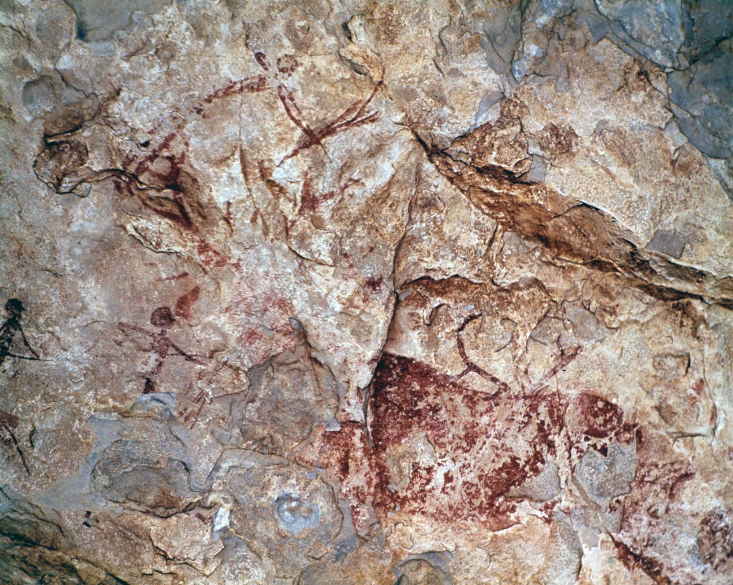
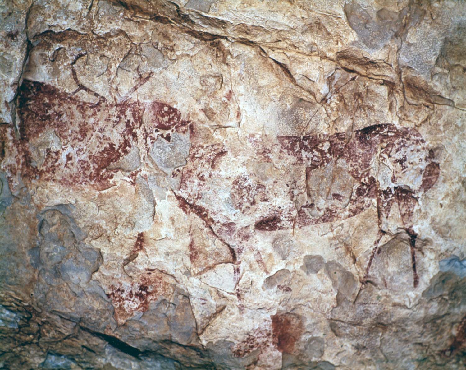
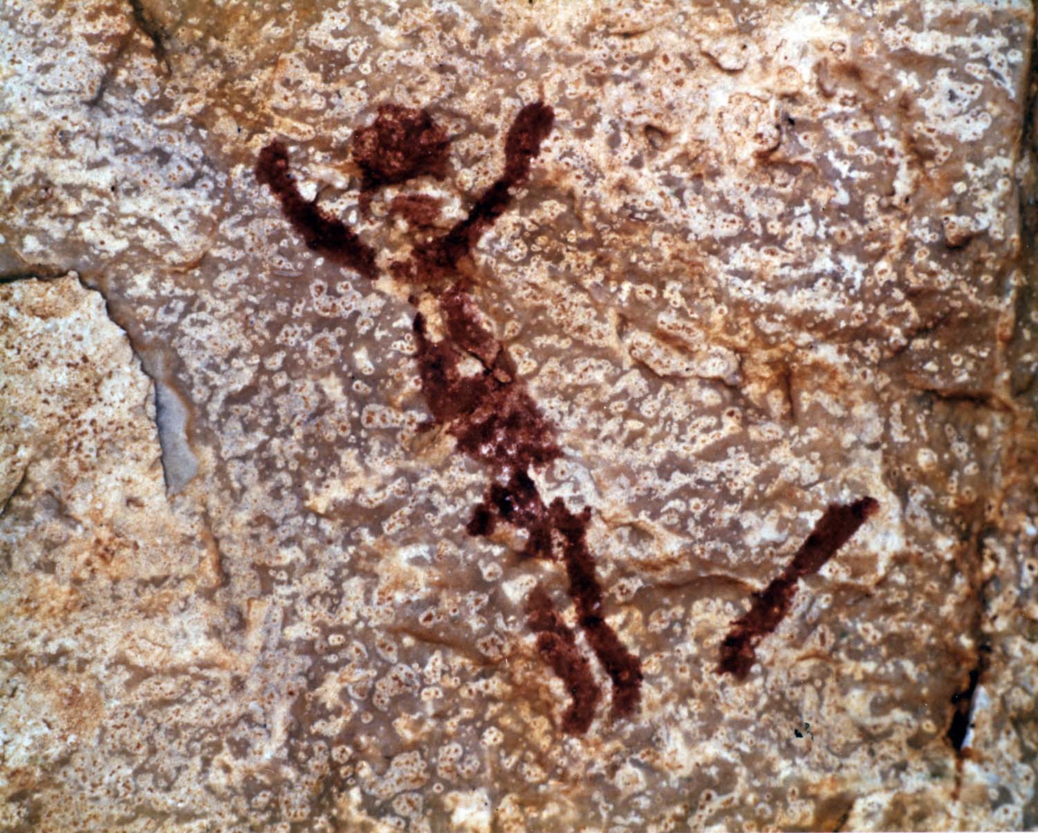
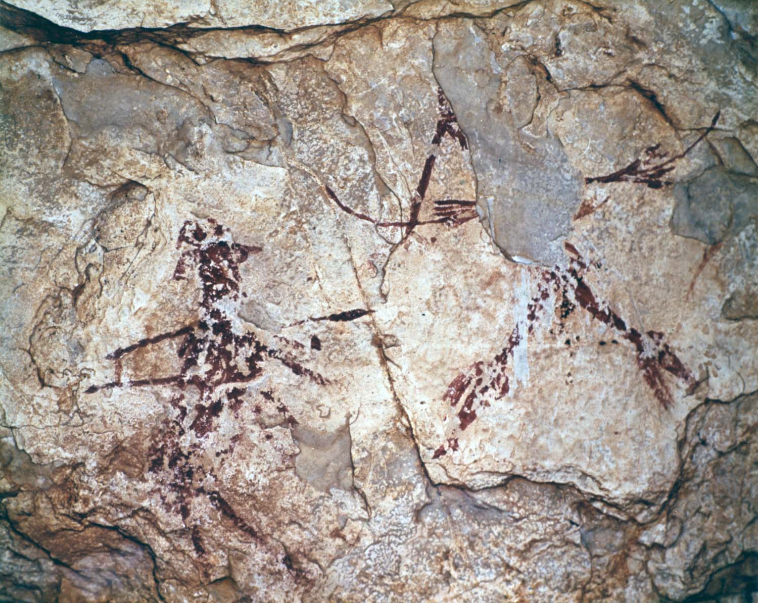
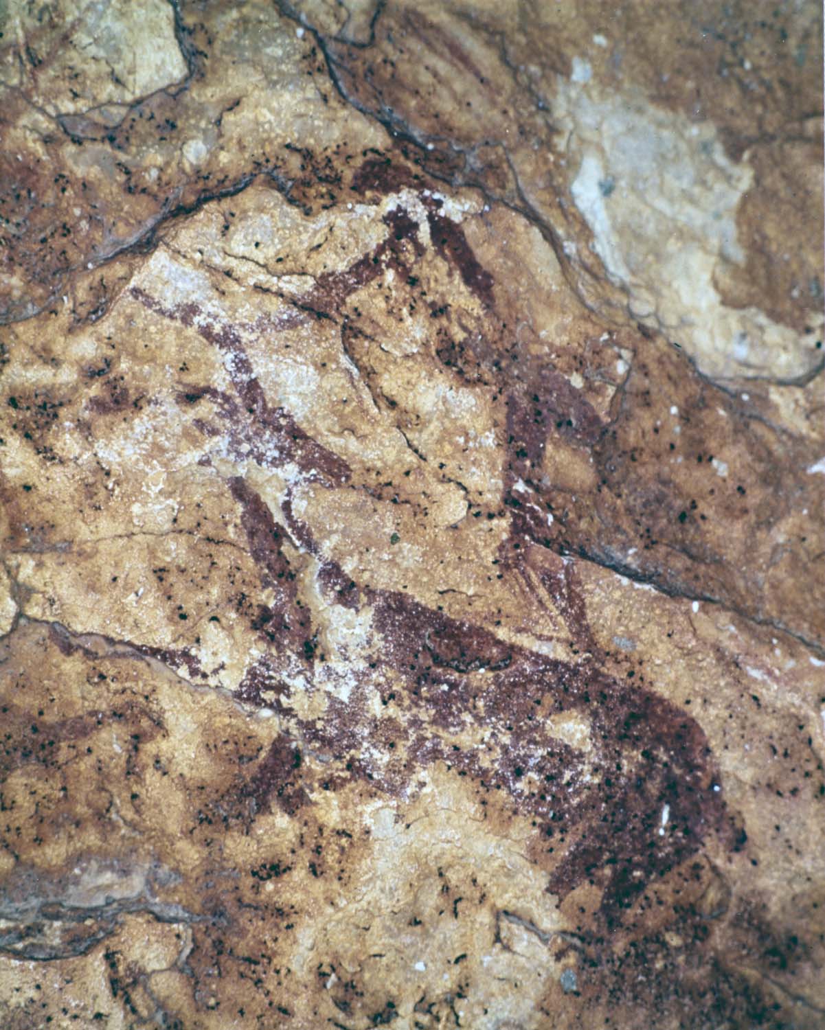
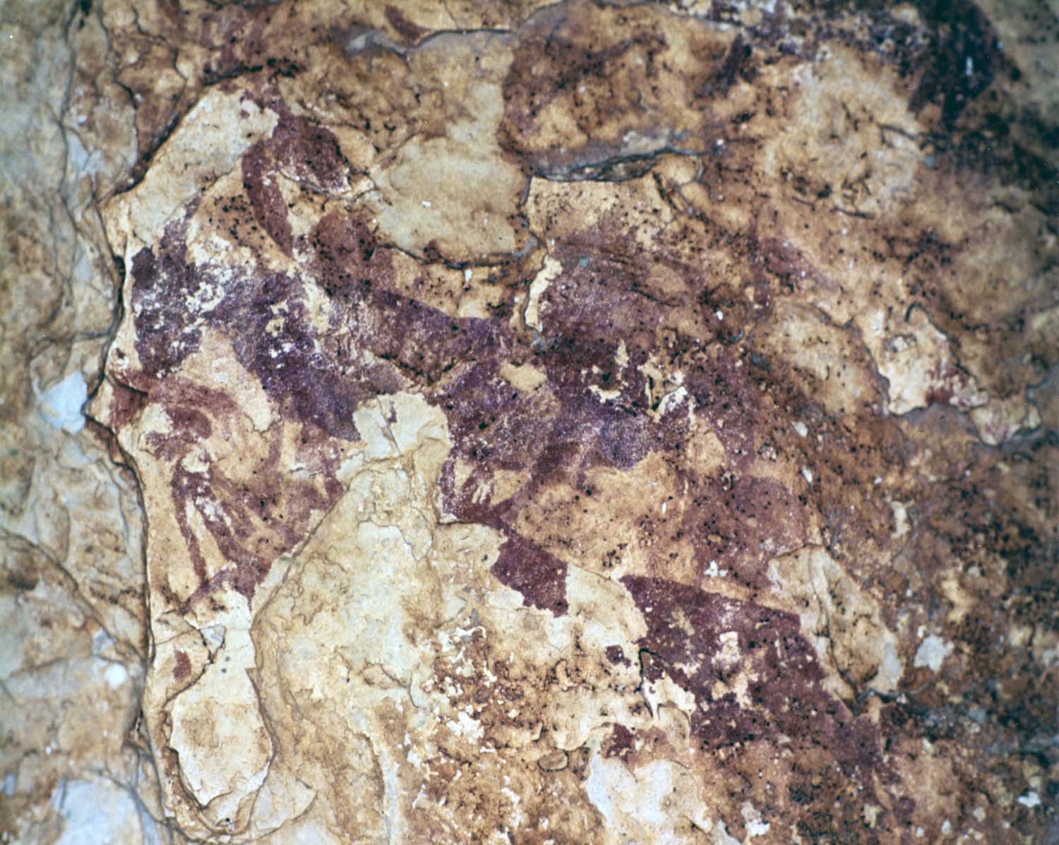
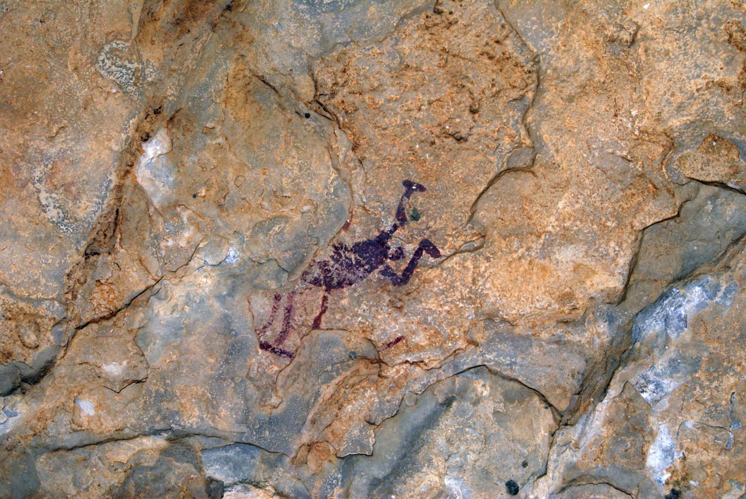
El descubrimiento del abrigo o Cova dels Rossegadors se produjo gracias a la construcción del embalse o pantano de Ulldecona, una presa de 64 m de altura con una capacidad de 15.000.000 de metros cúbicos, la cual precisó de los trabajos de perforación con maquinaria y dinamita para crear una carretera a través de las capas calizas de la margen izquierda del Río Sénia. Con el fin de resguardar el material explosivo se eligió un abrigo rocoso cercano. Sus pinturas rupestres fueron localizadas en otoño de 1947 por un obrero del que se desconoce su nombre el cual informó al encargado de las obras, José Lores, quien difundió el hallazgo.
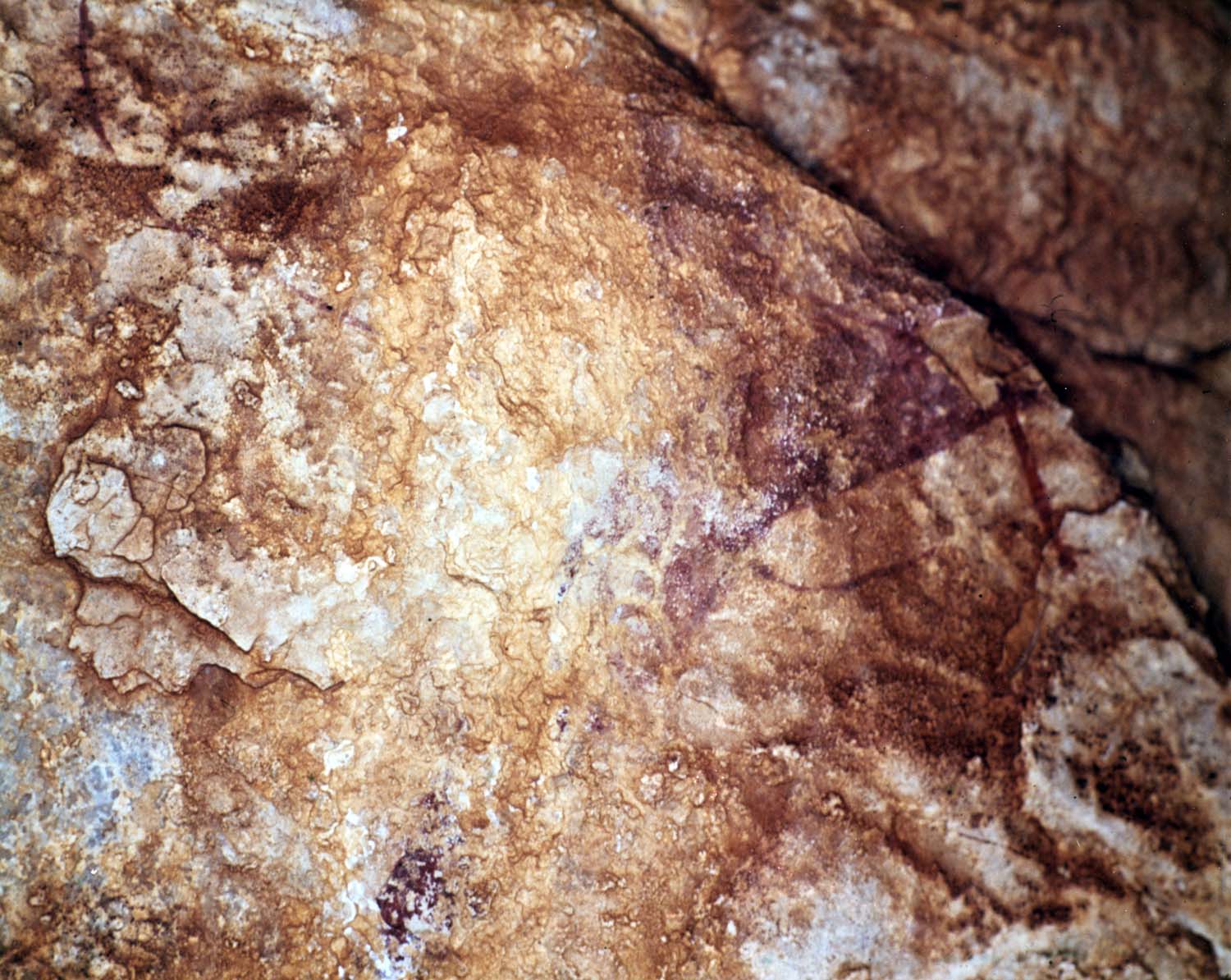
Salvador Vilaseca se enteró de la noticia unos meses después y acudió el 17 de abril de 1948, cuando realizó las primeras fotografías y calcos con la ayuda de su hija Lluïsa Vilaseca. Según este autor, en los documentos oficiales de las obras, el topónimo del lugar consta como la «cueva del Segundo Barranco dels Rossegadors», además anotó que, en su interior, se construyó una caseta de seis metros de longitud, una obra de albañilería para almacenar mil kilos de explosivos. El cemento para la edificación de la citada garita, pegada a la pared del abrigo, afecto a toda esta área y en con- secuencia a determinadas representaciones rupestres. Al finalizar la presa, el polvorín fue eliminado de la cavidad y la marca dejada por el cemento en la pared, visible todavía, venía a cubrir un espacio de 2,50 m de amplitud por 2 de altura. Salvador Vilaseca, subvencionado por la Comisaría General de Excavaciones Arqueológicas, regresó en diversas ocasiones para completar su trabajo, del que publicó un informe de carácter provisional: Las pinturas rupestres de la Cueva del Polvorín, donde señaló que: «Su estudio completo y definitivo esperamos publicarlo en colaboración con el profesor Pericot y con la que solicitamos de don Juan Porcar...» (Vilaseca, 1947). Estudio que nunca llego a realizarse.
Sobre el lamentable estado de conservación de algunas pinturas rupestres, Vilaseca indicó que «En la pared del fondo de la cueva se observan algunos descostrados de la roca debidos a los impactos de las explosiones». Y añadió que: «... la construcción del polvorín, [...] ha ocasionado la perdida de pinturas, algunos des cuyos restos se observan cubiertos por capas de cemento y humo.» (Vilaseca, 1947).
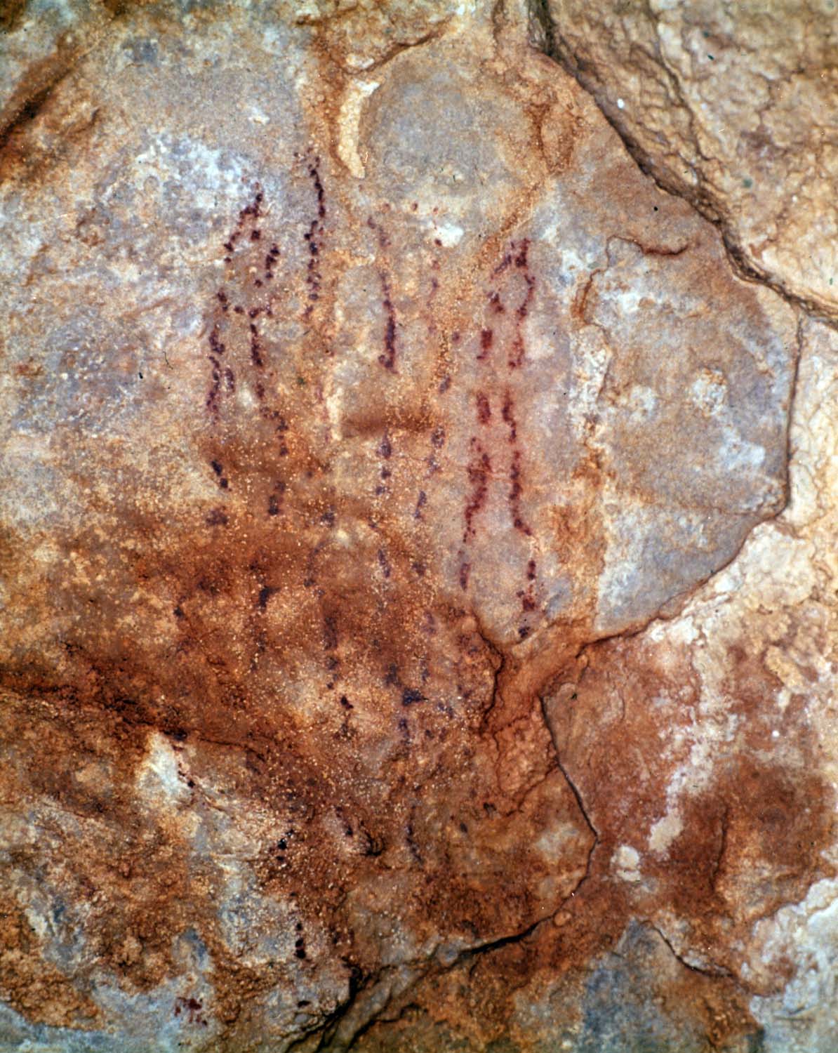
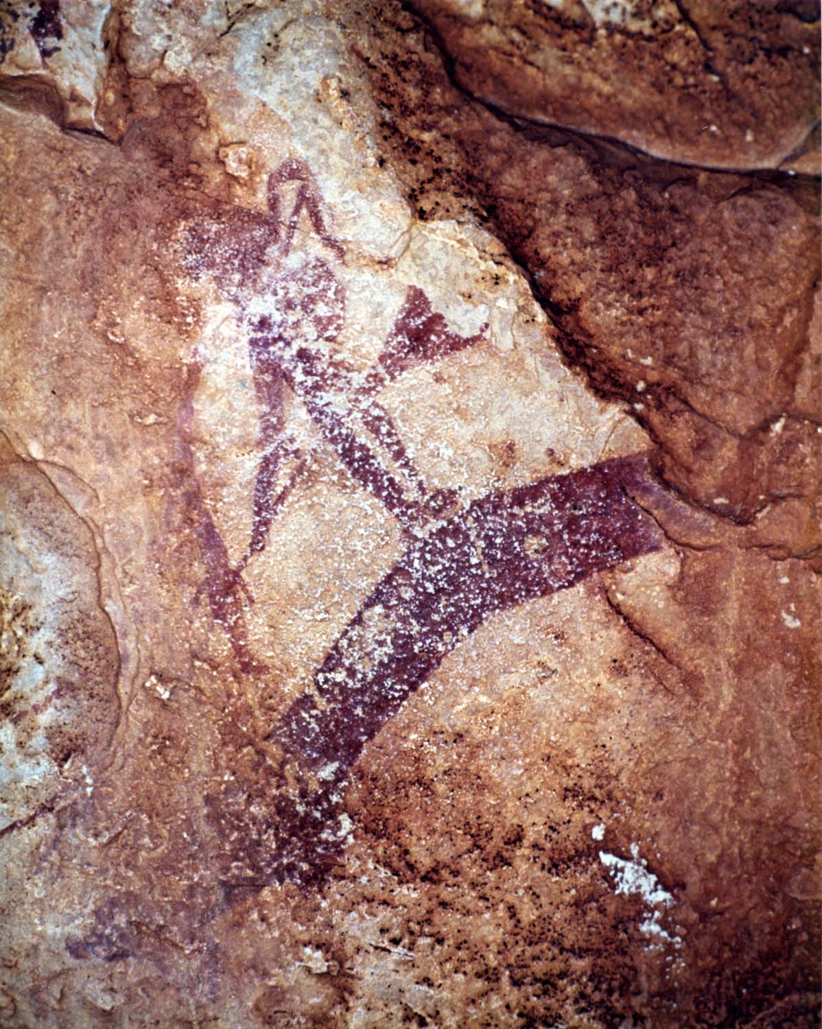
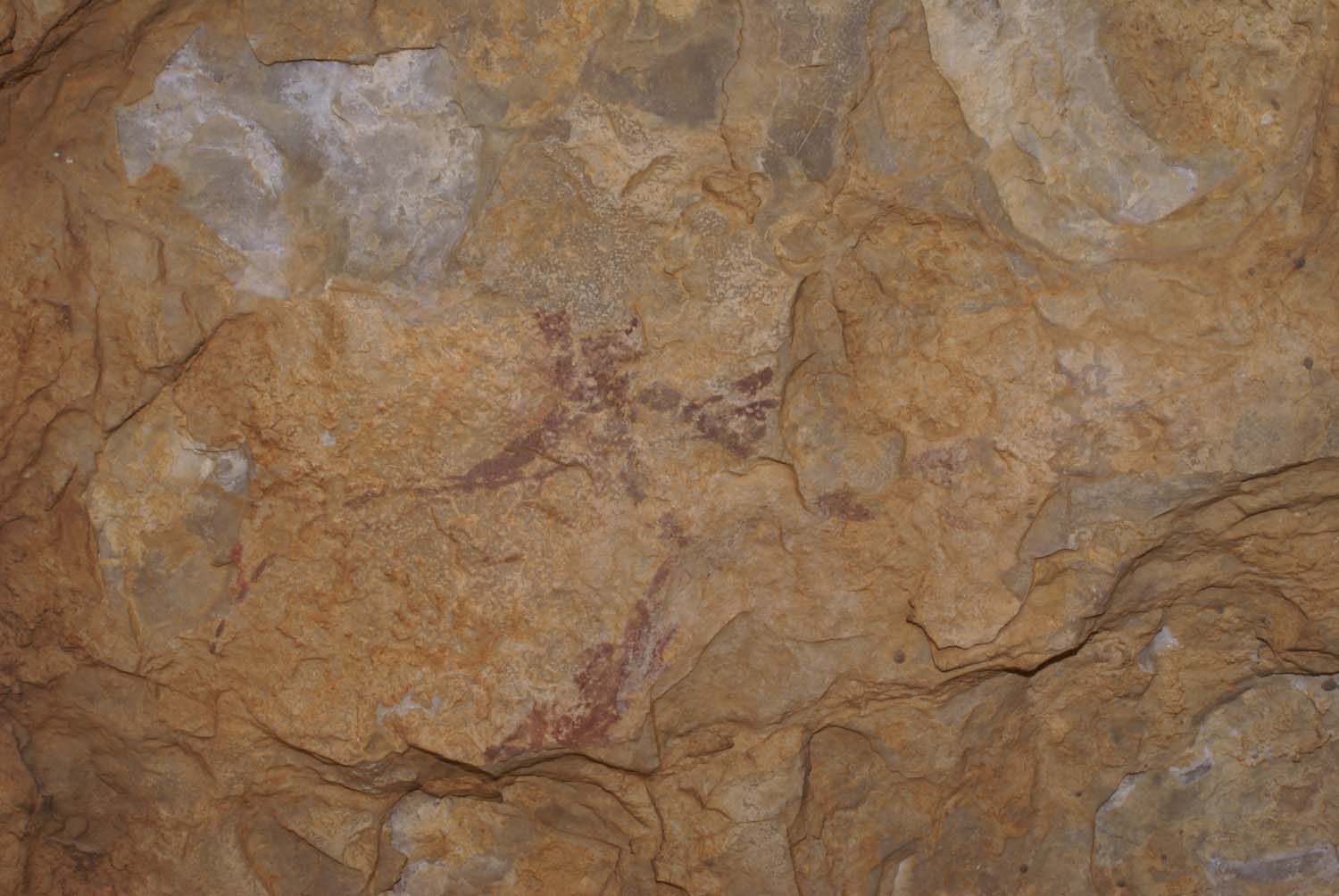
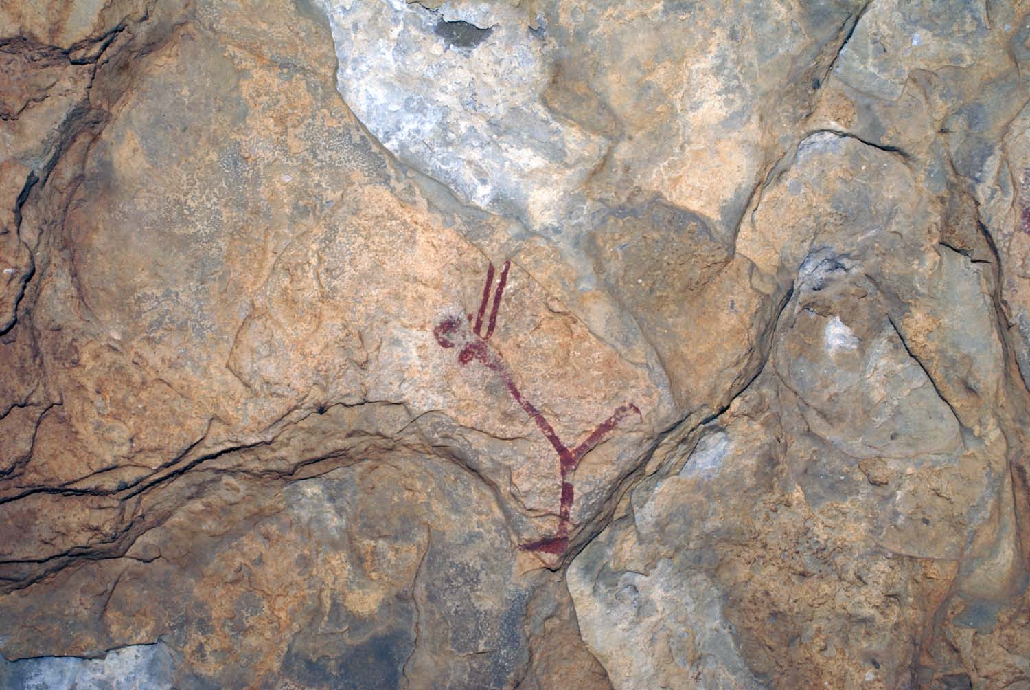
Por su parte, el religioso y profesor de Ciencias Naturales de la Sènia, Juan Cañigueral, publicó aquel mismo año (1948) un artículo en la revista Ibérica, núm. 148, titulado «Nueva localidad de pinturas rupestres en Cataluña. La Cova dels Rossegadors de la Sénia» describió el panel pintado, que situó en las últimas etapas del Paleolítico, y adjuntó algunos de sus dibujos. Según su interpretación las pinturas tendrían un fin, probablemente, religioso. Este autor se extrañó que no se hubieran descubierto mucho antes las pinturas, pues la cavidad se hallaba situada «...a pocos pasos de un camino de mucho transito, el principal para los pueblos de la tenencia del antiguo monasterio de Benifazá» (Cañigueral, 1948).
Después del informe de S. Vilaseca, con fecha de 1947, Juan Cañigueral no tardó en sacar a la luz otro artículo en la citada revista Ibérica, núm. 174 (1949) con el titulo «Más sobre la Cova dels Rossegadors», con el fin de aclarar algunas consideraciones en torno al trabajo de Salvador Vilaseca. El autor hizo alusión a los topónimos del paraje donde se ubica la cavidad, con el propósito de recobrar el antiguo nombre del lugar y señalando los siguientes términos: Barranc dels Rossegadors, Cova dels Rossegadors y Ullalt dels Rossegadors, en su artículo Cañigueral insistió en llamarle Cova dels Rossegadors. Asimismo, relata la historia sobre los límites territoriales de la zona y finalmente elogia los dibujos y calcos de Vilaseca.
Años después, las pinturas de la Cova dels Rossegadors fueron citadas y recogidas por otros autores como Antonio Beltrán en el Arte Levantino (1968), y Norberto Mesado (1989a y b), quien presentó un par de trabajos sobre las pinturas que habían quedado sin publicar en el trabajo precedente de Vilaseca, algunas de las cuales, solo habían sido mencionadas; la mayoría de ellas situadas en el interior de la caseta del polvorín y zona periférica.
Situación
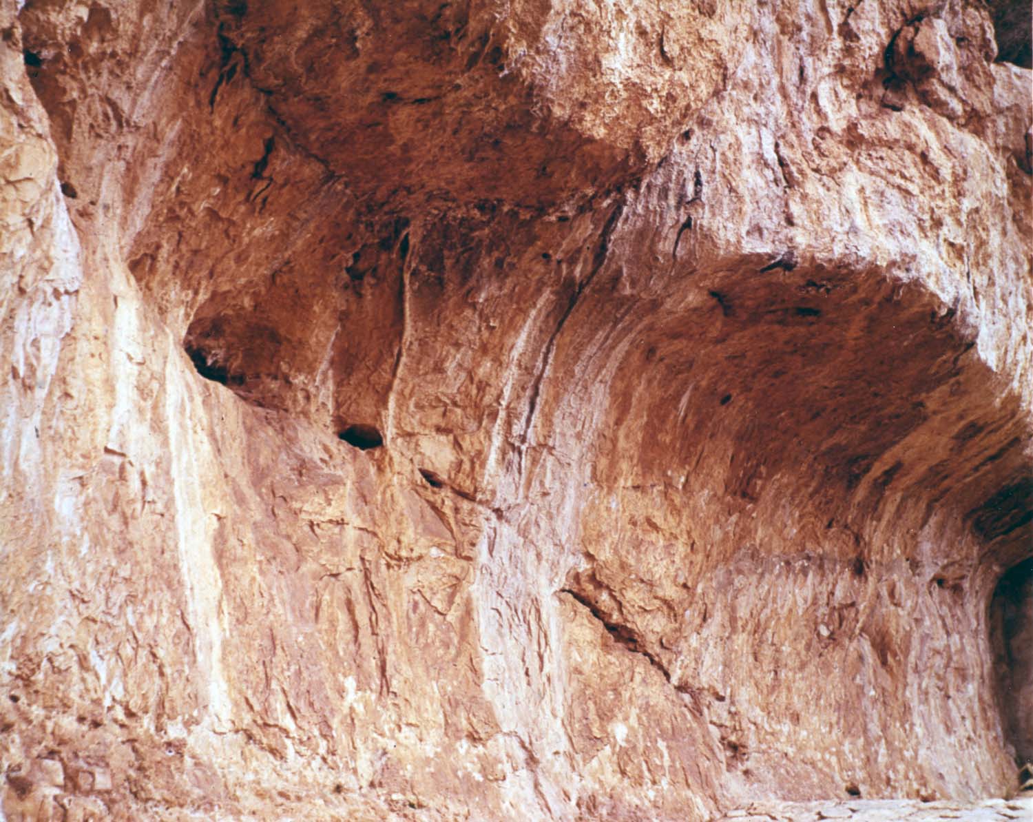
El conjunto rupestre de la Cova dels Rossegadors se localiza a unos 7 km al norte de la población de La Sénia (Tarragona), en un paraje quebrado y excepcional, dentro del llamado «segundo barranco dels Rossegadors», en las estribaciones meridionales de los “Ports de Tortosa-Beseit”, entre La Portella del Pinell (1099 m) y La Tossa (864).
Los escarpes donde se ubica la cavidad constituyen la vertiente sur de la Serra del Castellar, entre los barrancos de Mangraner y Fitó. Un entorno abrupto donde el relieve, que da paso al río Sènia, se estrecha formando un imponente escenario con las escarpadas paredes de Les Rabosses y els Rossegadors. El abrigo se halla en la ladera izquierda de un meandro del cauce y prácticamente en el inicio del citado «segundo barranco» tributario del Río Sénia. Desde este enclave se distinguen, además de los riscos de Les Rabosses, la Penya de l’Àliga (796 m) y La Tossa (950 m).
Para su localización es preciso tomar la carretera que, desde la población de La Sénia, se dirige hacia el norte —Sant Pere y el Molí del Abad— y nos conduce a las localidades de Bellestar, la Pobla de Benifassà, Coratxar, Castell de Cabres y Fredes. Poco antes de llegar al embalse y antes de cruzar el río hacia la izquierda, debemos dejar la carretera para desviarnos por una pista particular (perteneciente a los terrenos de la Confederación Hidrográfica del Júcar), la cual asciende a la vivienda del guarda de la presa y por donde se accede a la cavidad.
El conjunto ha permanecido cerrado al turismo en general, sin embargo, el antiguo guarda de la presa, el Sr. Constantino Navarro, —hoy jubilado— acompañaba generalmente a los visitantes interesados, lo que ayudó a frenar el deterioro antrópico que había sufrido en épocas anteriores. Además, la zona es asiduamente frecuentada por los pobladores locales ya que en la base de la cavidad, nace una fuente caudalosa conocida como de Els Rossegadors.
ENGLISH
Background
The discovery of the shelter or Cova dels Rossegadors took place thanks to the construction of the reservoir or reservoir of Ulldecona, a dam of 64 m high with a capacity of 15,000,000 cubic meters, which required the work of drilling with machinery and dynamite to create a road through the limestone layers of the left bank of the Sénia River. In order to protect the explosive material, a nearby rock shelter was chosen. His cave paintings were located in the autumn of 1947 by a worker whose name is unknown, who informed the person in charge of the works, José Lores, who spread the discovery.
Salvador Vilaseca heard the news a few months later and went on April 17, 1948, when he made the first photographs and decals with the help of his daughter Lluïsa Vilaseca. According to this author, in the documents or documents of the works, the toponym of the place is known as the "cave of the Segundo Barranco dels Rossegadors, also noted that, inside, a house of six meters in length was built, a work of masonry to store a thousand kilos of explosives. The cement for the construction of the aforementioned garita, attached to the wall of the shelter, affected all this area and consequently to certain rock representations. At the end of the dam, the powder magazine was removed from the cavity and the mark left by the cement on the wall, still visible, came to cover a space of 2.50 m in width by 2 in height.
Salvador Vilaseca, subsidized by the General Commissariat of Archaeological Excavations, returned several times to complete his work, of which he published a provisional report: The cave paintings of the Polvorín Cave, where he pointed out that: "His complete and definitive study we hope publish it in collaboration with Professor Pericot and with which we requested Don Juan Porcar …” (Vilaseca, 1947). Study that never came to fruition.
About the lamentable state of conservation of some cave paintings, Vilaseca indicated that “In the wall of the bottom of the cave you can see some of the rocks that have been uncovered due to the impacts of the explosions". He added that: "... the construction of the powder magazine, [...] has caused the loss of paintings, some of whose remains are covered by layers of cement and smoke." (Vilaseca, 1947).
For his part, the religious and professor of Natural Sciences of the Sénia, Juan Cañigueral, published that same year (1948) an article in the Iberian magazine, núm. 148, entitled «New locality of cave paintings in Catalonia. The Cova dels Rossegadors de la Sénia described the painted panel, which he placed in the last stages of the Palaeolithic, and attached some of his drawings. According to his interpretation the paintings would have an end, probably, religious. This author was surprised that the paintings had not been discovered much earlier, because the cavity was located "... a few steps from a road with a lot of traffic, the main one for the towns of the possession of the old monastery of Benifazá" (Cañigueral, 1948).
After the report of S. Vilaseca, dated 1947, Juan Cañigueral soon brought to light another article in the aforementioned Iberian magazine, no. 174 (1949) with the title "More on the Cova dels Rossegadors", in order to clarify some considerations regarding the work of Salvador Vilaseca. The author alluded to the place names of the place where the cavity is located, with the purpose of recovering the old name of the place and indicating the following terms: Barranc dels Rossegadors, Cova dels Rossegadors and Ullalt dels Rossegadors, in his article Cañigueral insisted on calling him Cova dels Rossegadors. He also tells the story about the territorial limits of the area and finally praises the drawings and decals of Vilaseca.
Years later, the paintings of the Cova dels Rossegadors were cited and collected by other authors such as Antonio Beltrán in Arte Levantino (1968), and Norberto Mesado (1989a and b), who presented a couple of works on the paintings that had not been published in the previous work of Vilaseca, some of which had only been mentioned; Most of them are located inside the pullet house and peripheral zone.
Situation
The cave group of the Cova dels Rossegadors is located about 7 km north of the town of La Sénia (Tarragona), in a broken and exceptional landscape, within the so-called "second ravine dels Rossegadors", in the southern foothills of the Ports from Tortosa-Beseit, between La Portella del Pinell (1099 m) and La Tossa (864). The escarpments where the cavity is located constitute the southern slope of the Serra del Castellar, between the ravines of Mangraner and Fitó.
An abrupt environment where the relief, which gives way to the Sénia River, narrows forming an imposing stage with the steep walls of Les Rabosses and els Rossegadors. The shelter is on the left side of a bend in the channel and practically at the beginning of the aforementioned "second ravine" tributary of the Sénia River. From this enclave are distinguished, in addition to the cliffs of Les Rabosses, the Penya de l'Àliga (796 m) and La Tossa (950 m).
For its location it is necessary to take the road that, from the town of La Sénia, goes to the north -Sant Pere and the Molí del Abad- and leads us to the towns of Bellestar, the Pobla de Benifassà, Coratxar, Castell de Cabres and Fredes. Shortly before reaching the reservoir and before crossing the river to the left, we must leave the road to deviate through a particular track (belonging to the land of the Júcar Hydrographic Confederation), which ascends to the house of the guard of the dam and where the cavity is accessed.
The whole has remained closed to tourism in general, however, the former guard of the dam, Mr. Constantino Navarro, now retired, usually accompanied interested visitors, which helped to slow down the anthropogenic deterioration that had suffered in times previous In addition, the area is regularly frequented by local residents because at the base of the cavity, a large spring known as Els Rossegadors is born.The whole has remained closed to tourism in general, however, the former guard of the dam, Mr. Constantino Navarro, now retired, usually accompanied interested visitors, which helped to slow down the anthropogenic deterioration that had suffered in times previous In addition, the area is regularly frequented by local residents because at the base of the cavity, a large spring known as Els Rossegadors is born.